Cloud Base and Common Sense: Picking the Right Hill for the Weather You've Got
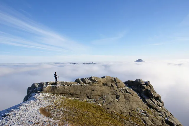
Photo: Peter Standing, CC BY-SA 2.0, via Wikimedia Commons
There's a particular kind of heartbreak in opening the Mountain Forecast page at 9pm the night before a big hill day and watching the cloud base symbol sink to 300 metres. You've booked the Friday off, the flask is filled, the map is folded to the right page — and the mountain has other ideas.
But here's the thing the old hands know: a bad forecast is rarely a bad forecast for every hill. Britain's summits are not equal opportunities for misery. Some catch their own weather, some shrug off a front, and some hide below the cloud when everything else is white. Learning the difference is what separates a wasted drive from a surprisingly brilliant day.
Why Your Hill Has Its Own Microclimate
Mountains make weather as much as they receive it. Air is forced upwards over high ground, cools, and dumps its moisture on the windward side — which is why the western fells of the Lake District are sodden while the eastern fells sit in the rain shadow, often a category or two drier.
Once you internalise that, the forecast starts making sense. Helvellyn in a south-westerly will be clagged and grim on its flanks while the Howgills, twenty miles east, might be riding clear. The Cairngorms generate their own cloud so reliably that lenticular lens-shaped caps over Cairn Gorm are practically a local institution — beautiful from the car park, miserable from the summit plateau.
Some hills are simply notorious. Pen-y-ghent and its Whernside and Ingleborough neighbours sit in the path of damp westerlies and famously brew their own clag, which is why plenty of Three Peaks veterans will tell you they saw precisely one trig point in four. Meanwhile, the dry Eastern Caingorm corries or the ridges of Snowdonia's Glyderau on a firm frosty day can be far kinder than the lowlands suggest.
Reading the Forecast Like a Local
The Met Office mountain forecasts, MWIS and Mountain Forecast all deserve a look — they often disagree, and the disagreements are informative. But it's the details that matter:
- Cloud base versus summit height. A 700m base is fine for Latrigg, terminal for Scafell Pike. Compare the two numbers before you commit.
- Wind direction, not just speed. Windward slopes take the weather; leeward ones often don't. A brisk westerly might mean you choose the drier eastern Dales over the western Lakes.
- The freezing level. In winter, this single number transforms a boggy trudge into a crampon day or a no-go. Above it, expect ice on paths, not just on summits.
- Timing of the front. A band of rain arriving at 4pm is a completely different proposition from one sitting on you all day. Fronts move; you can move faster.
And then there's the oldest forecasting tool of all: the sky. Towering cumulus building by late morning means convection and afternoon showers — get up early, get down early. Flat grey stratus that never lifts is usually stable and merely dreary. A red sky at night, for once, genuinely means something when you're standing in a bothy.
Hills That Forgive, Hills That Punish
If the forecast is middling, pick a hill that plays nicely. The grassy, well-drained Wainwrights of the eastern fells — think High Rigg or Walla Crag — are pleasant enough under grey skies and dry out quickly after rain. The Welsh coastal hills and the Scottish west coast islands can surprise you: sea-level cloud often tops out below 600m, leaving the summit bathed in sunshine while the mainland drowns.
Conversely, save the big plateau days for the good windows. The Cairngorms in cloud are a navigation exercise first and a walk second; the remoteness of Knoydart or the Arans means a clagged-in day out there is genuinely serious. These are your blue-sky-bullet hills. Keep them in reserve.
Build a Flexible Bagging List
The real skill isn't reading the forecast — it's having a list elastic enough to bend with it. Try structuring yours in three tiers:
- The trophy list. Big, remote, weather-dependent. These get the settled high-pressure weekends.
- The all-rounder list. Solid hills with good paths, escape routes and shorter tops — fine in wind, tolerable in drizzle.
- The bad-weather list. Low, quick, close to the car, with a decent pub at the end. Marilyns under 400m, coastal hills, forested tops with shelter.
Then, the night before, match the forecast to the tier. It sounds obvious, but most ruined hill days come from stubbornness — the refusal to swap the planned summit for a sensible alternative twenty miles east in the rain shadow.
The Forecast Isn't the Whole Story
One last thing: the forecast is a probability, not a promise. Mountain weather changes on its own schedule, and the view from the valley is worth more than any chart. Look up. If the clag is lifting at 8am when the app said noon, crack on. If the lenticulars are stacking over the plateau, maybe today's the day for the bad-weather list and a long lunch instead.
Britain gives you thousands of summits and roughly four reliable forecast windows a month. The baggers who tick consistently aren't luckier than you — they're just better at matching the hill to the sky. Get that right, and even the filthiest weekend yields something worth climbing.